Hello, hurricane season: Is Pinellas County ready?

Part 1 of 2.
On Thursday, May 23, 2024, clouds formed over eastern Cuba.
These unremarkable clouds, accompanied by a smattering of rain, represented something much greater: The first activity of the 2024 Atlantic hurricane season, which may be the most active – and the most damaging – ever.
The climate science team at the University of Missouri expects 26 named storms this year. Hurricane expert Dr. Phil Klotzbach at Colorado State says 23. The National Oceanographic and Atmospheric Administration (NOAA) – the country’s foremost hurricane authority and the operator of the famed ‘Hurricane Hunters’ expects 24, while scientists at the University of Pennsylvania went so far as to call for 33 storms – blowing past the record of 30 set in 2005 and 2020.
On the official opening day of the 2024 hurricane season, whether those projections will become reality is unknown – as is whether they will disrupt the charmed, storm-free existence Tampa Bay has enjoyed for more than a century. Over the past two weeks the Catalyst spoke to meteorologists, local officials and others to find out what we can expect, how communities are preparing – and whether it will be enough when (not if) The Big One comes.
Hurricane Amnesia
Florida history is defined by hurricanes. They are to this state what tornadoes were to Dorothy’s Kansas.
A storm at Fort Caroline in 1565 destroyed a French fleet and with it their efforts to colonize the state. The 1928 Okeechobee hurricane killed thousands of migrant laborers, inspiring the first major flood control efforts in South Florida – and Zora Neale Hurston’s great Florida novel, Their Eyes Were Watching God. Hurricane Andrew in 1992 destroyed whole communities but resulted in almost no loss of life – a crucial passed test for a rapidly growing state.
For Tampa Bay, what is unique is not how much these storms have defined us, but how little. In 103 years no major hurricane has directly hit the region, and it still requires a trip into the hazy past to see the last time any hurricane made landfall. Both of these storms occurred before the invention of air conditioning – and Florida’s rapid all-year population growth. Tampa Bay has 11 residents today for every person who lived here in 1950.
Denis Phillips, ABC Action News’s longtime chief meteorologist, calls it “hurricane amnesia.”
“‘It missed us before, it will miss us again,’” he said, echoing the sentiments of many long-time residents. “So far, that’s worked out … but it won’t always be that way.
“Models are changing for the better,” he elaborates. “The short-term forecast track really is superior to what it was two decades ago. Unfortunately, the apathy many Floridians have hasn’t changed … and it probably won’t until someone actually faces the threat of a major hurricane. Once they face that, usually the apathy goes away forever.”
Stormchaser Mike Boylan, host of Mike’s Weather Page, whose daily hurricane season updates are viewed by thousands, remembers how his attitude towards storms changed once he began driving into them.
“Seeing the effects of storms right after [they hit] woke me up to how awful the conditions can be in so many different ways. I could never fathom before I saw it.”
For long-time residents like him, “We’ve evacuated so many times … my biggest fear is that the [next] time around, people aren’t going to evacuate. But there’s gonna be one time where it doesn’t turn.”
To elected officials responsible for planning for just that eventuality, this apathy is a source of frustration – and danger.
“We’ve been complacent for many years and [people] believe the Tocabaga are protecting us,” said Pinellas County Commissioner Kathleen Peters, referencing a popular myth relating to the presence of Indian burial grounds repelling hurricanes in the region.
“John’s Pass was created [by the hurricane] in 1848. We’re past due.”

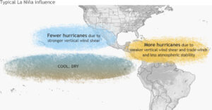
How La Nina works. Image: NOAA.
A Goldilocks environment
Amongst the local weather community, the consensus was that the “off the charts” projections for this season were reasonable – even measured.
“I haven’t seen this many forecasts over 21 ever,” Boylan noted, referring to the number of hurricane names set aside each year by the World Meteorological Organization. That list has been exhausted just twice before – 2005 and 2020. 2024 could be the third.
The reason is that conditions are just right for the development of many storms – and big ones. “With the combination of La Nina and very warm waters, there is no way we don’t see an above average season,” noted Phillips.
“La Nina” is the companion phenomenon to the “El Nino – Southern Oscillation,” or ENSO. These are weather phenomena in the east-central Pacific that have a knock-on effect into the Atlantic. A typical ENSO cycle features strong upper level wind shear over the Caribbean and Atlantic that shreds hurricanes, inhibiting development and growth. In a La Nina, that wind shear disappears, making conditions much more favorable. La Nina typically foreshadows more storms, stronger storms, and storms more likely to rapidly intensify, where they can escalate from a weak system to a monster Category 4 or 5 within 18-24 hours.
The second is water temperature. Hurricanes are caused by warm, moist air being sucked into the atmosphere, where they form storms. As storms strengthen, they lift more warm surface content and begin to rotate around a center, forming the distinctive ‘eye.’
Hurricanes require warm water – specifically, surface ocean temperatures of at least 79 degrees. On May 31 Key West clocked at 90 degrees, more than 7 degrees higher than the May average. Atlantic readings are similarly 6-8 inches warmer than normal, and the Caribbean recently hit 84.7 degrees Fahrenheit, its hottest ever reading before August. Warmer surface water means more storms, and stronger storms. Warm surface water also means more and heavier tropical rainfall – as much as 5x more. These warm surface temperatures were why, despite 2023 being an El Nino year, it was well above average in the number of storms.
None of this means hurricanes are guaranteed to hit the Tampa Bay area. “It should be noted that in the bay area, there are no numbers supporting [that] a more active year means a higher landfall percentage in our area. The Panhandle, yes. The East Coast, yes. The Northern Gulf Coast, yes. But for our area, the numbers just don’t support it.
“The position of the Bermuda High is everything. Where it sets up pretty much what drives the track of these storms,” said Phillips. The Bermuda High refers to an atmospheric high pressure system over the Atlantic – hurricanes, which are low pressure systems, swerve clockwise around the high like a car dodging a pothole. When the high settles near or over Florida, it sends storms around Tampa Bay. Its weakening as fall approaches is one reason dangerous storms become more common in August and September.
Boylan stressed the limitations of projections. “I don’t consider the risk to be different one year versus the other anymore,” he said. “Don’t stress about the numbers – it’s that one storm. Unless you lived in Perry, 2023 was a quiet year.”
“It only takes one landfall,” Phillips emphasizes, “to make it a busy season.”
Efforts to prepare
The work of forecasters and meteorologists like Boylan and Phillips are the first line of defense as the season starts. While the arrival of The Weather Channel’s Jim Cantore serves as the harbinger of doom on social media, local sources are usually the first source – and the best – for information for those in the path.
Those forecasters begin preparing months in advance to understand the year’s forecasts, examine long-range models and make sense of what they can expect – and when. As a storm approaches, Phillips’ team works to a 12 hours on, 12 hours off schedule – though by landfall, it’s usually all hands on deck. As a storm threatens Phillips himself is probably either on the air or on his Facebook Live, clad in his distinctive ‘Rule #7’ hoodie (“Stop freaking out … until I tell you to. We’re fine.”)
By then, Mike Boylan may have switched from his home studio to the road, heading as close to the site of landfall as he can get. Boylan was among the first to share pictures of the devastation from Hurricane Idalia, the only major landfall of 2023.
But forecasters are not the only ones preparing well in advance this year. Pinellas County and its municipalities, including St. Petersburg, have year-round Emergency Management departments war-gaming their response to disasters – and learning from years past.
Coordinating with the Florida Health Pinellas, the Sheriff’s Department, Pinellas County Schools and others, the Pinellas County Emergency Management Department “prepares all year round,” noted Commissioner Peters. “We’ve gotten the process pretty perfected.”
Two years ago, that effort included consultation with the National Hurricane Center to update the County’s hurricane evacuation zones, according to County Planning and Preparedness Manager Stephanie Hendrix. With that update tens of thousands more citizens will be required to evacuate in future storms, but the maps paint a much more realistic picture of the impact of significant storm surge on Pinellas County – which in a major surge event would become the Gulf Coast’s newest, and largest, barrier island.
In addition to updating flood zones and the County’s Hurricane Guide, Pinellas County Emergency Management focused heavily on partnering with Pinellas County Schools to teach hurricane preparedness to children and families. They collected supplies at drives across 21 local campuses, held contests and conducted teach-ins for both faculty and students, and dispatched teams of 11 Youth Ambassadors from Pinellas Park High School last November to present on hurricane awareness. They continue to outreach to vulnerable communities, such as families with special needs and the deaf; added Starlink satellites for additional communications in a disaster; and run self-service sandbag sites, companions to those operated in St. Petersburg and other cities.
(Sandbags remain both inevitable and controversial hurricane preparation tools – the long lines at distribution centers have become a rite of passage for new residents. While their effectiveness may be limited, both city and county officials agreed with Boylan when he said, with only a hint of exasperation, “It’s not to protect your home; it’s to protect your doorway.”)
Not all the County’s preparations have gone according to plan. For beach communities, healthy, well-maintained sand dunes are critical first lines of defense against storm surge. Stalled renourishments have raised the risk of significant flooding even with comparative small storms or limited surge, according to Commissioner Peters. Emergency dunes placed after Idalia have already been damaged by winter storms and would be at risk of failing completely in another storm. The result is that sand elevation is six feet lower than previous years along beach communities, leaving almost all at risk of inundation in a major storm.
In St. Petersburg, efforts have been taken to pro-actively mitigate flood impacts in low-lying areas, said Councilmember Gina Driscoll, who represents a low-lying district covering downtown and southeast St. Pete.
“Our city has always done a great job of preparing for storms, whether it’s clearing storm drains or making sandbags available,” said Driscoll. She specifically cited the early installation of backflow preventers in flood-plagued Shore Acres, noting that the Council approved an accelerated purchase timeline to get more than 40 preventers in place for the peak of storm season.
Private companies and nonprofits are not sitting idle, either. Duke Energy recently unveiled a new mobile command center to aid power restoration in a disaster. Sol Relief, an airborne disaster relief organization that’s delivered more than a million pounds of supplies since 2017, is busily conducting both fundraising for their transnational efforts and disaster training for volunteers closer to home. “If the past storm seasons have taught us all anything, it’s that preparation and safety are key, and we all need to be prepared and take safety precautions before, during, and after a storm,” Harris Ambush, Sol Relief’s Executive Director, told the Catalyst.
With everyone ramping up for hurricane season, it may seem impossible that any community could be as amply prepared as the cities and towns of Pinellas County. But that obscures the X factor every expert cited when asked about their greatest concern going into storm season – the variable that is at once the source of the community’s resilience and its greatest risk:
You.
Monday: Part 2.


