Thrive
Pinellas officials brace for ‘unprecedented storm surge’

In August 2023, Hurricane Idalia’s roughly four-foot storm surge inundated the Pinellas County peninsula. Local officials expect significantly worse conditions Thursday.
County Commissioners held an emergency meeting at 10 a.m. Tuesday ahead of what is now Tropical Storm Helene. National forecasters expect rapid intensification and a Category 3 hurricane by the time it brushes the Pinellas coast Thursday afternoon.
The county is now under a hurricane watch, with 45 to 60 mph sustained winds and 75 mph gusts likely from Thursday morning through Friday afternoon. Administrator Barry Burton said his primary concern is an “unprecedented storm surge.”
“With it being less than a hundred miles offshore, and with a wind span of 250 miles, any small change in direction could have devastating conditions – and quickly worsen,” Burton added. “We only have one opportunity to prepare, and that’s now.”
He said evacuations are likely, but officials will wait for clarity on the fast-moving storm’s track before making those orders. They will first clear hospitals and long-term care facilities.
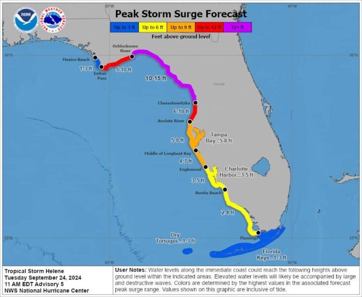
Burton said the forecasted eight-foot local storm surge is “far greater than anything we’ve seen.” However, he also noted that similar predictions have previously proved false.
Forecasters expect Helene to make landfall somewhere between Florida’s Panhandle and Big Bend area by Thursday evening. As of the National Hurricane Center’s (NHC) 11 a.m. update, Pinellas is no longer in the “cone of uncertainty.”
That could change. “It’s unpredictable,” Burton said. “So, we’re preparing for the worst and hoping for the best.”
The National Hurricane Center’s latest storm surge forecast. Screengrab.
Cathie Perkins, emergency management director, said Helene is a substantially larger storm than Idalia. She also noted its track to the west of Pinellas leaves the county on its “dirty side,” which is more likely to produce gusty winds, torrential rains and tornadoes.
Saturated ground from recent historic rainfall increases the likelihood of tropical-storm-force winds uprooting trees. “That means underground infrastructure being pulled up and overhead lines being pulled down,” Perkins said.
Projections call for the county to receive three to six inches of rain, with some areas recording up to 10 inches. Perkins said the saturated ground cannot absorb those forecasted totals.
“The other thing is that this storm surge and elevated water levels are expected to last for 24 to 36 hours, which means it’s going to take any rainfall that comes down time to drain off,” she added.
Perkins said a five-to-eight-foot storm surge would significantly surpass Idalia’s effects and does not include increased wave heights. County officials would evacuate inland areas if the NHC increases its forecast to 10 feet.
Commissioners declared a local state of emergency to ensure Sheriff Bob Gualtieri could take protective measures and Burton could make emergency purchases. Perkins said officials will discuss evacuation orders at a subsequent policy group meeting.
They rescheduled an 11:30 a.m. media briefing until 1:30 p.m. Perkins called the disaster.pinellas.gov website a one-stop-shop for residents that will highlight evacuation zones and open shelters.
“We heard horrifying stories during Hurricane Ian from people who didn’t know there were resources available, so they didn’t evacuate,” she said. “I want people to know that if we order evacuations, PSTA (Pinellas Suncoast Transit Authority) will offer free rides to shelters.”
Pinellas County Schools Superintendent Kevin Hendrick is part of the county’s policy group. Perkins said he is “working on” the district’s announcements regarding school closures.
Gualtieri encouraged people who live and work on barrier islands to apply for a scannable tag that allows immediate access during mandatory evacuations. He said stakeholders underutilize the program and must “sit in line with everyone else.”
Perkins plans to fully activate the Emergency Operations Center, now partially staffed, Wednesday morning. The county’s emergency information line (727-464-4333) is open 24 hours.
“Because this is such a fast-moving storm, you really do need to be paying attention,” said Commission Chair Kathleen Peters. “Things are going to happen quickly, and then you’re going to have to respond quickly if you want to protect your family, pets and property.”


SB
September 24, 2024at8:19 pm
It’s not our fault. It’s historic rainfall. And saturated ground.
It’s definitely not all the problems we’ve been telling you about with our infrastructure for decades.
It’s definitely not lack of maintenance or cleaning up flood control systems.
We are not responsible. Those canals that we see filled with debris… Just let us know and will give you the illusion of fixing it and then we won’t.
And you, the taxpayer will get to pay for the increased flood premiums. Uncovered losses. Giant deductibles. You know… All those things that make living here unaffordable.
But we’re going to have a great baseball stadium for all the people moving here so they can go to baseball games.
Which of course is no one because no one goes to baseball games anymore.
And then we’re going to provide you with wildly expensive government subsidized “affordable” housing. At $400,000 per unit and up if you do the math.
The worst idea of all time.