Thrive
USF College of Marine Science unveils automated coast-mapping vessel
In its continued quest to establish itself as a leader in marine science and coastal resiliency, scientists from the University of South Florida St. Petersburg have recently launched a new mission to map Tampa Bay’s shallow coasts.
Steve Murawski heads the Center for Ocean Mapping and Innovative technologies (COMIT) at the USF College of Marine Science (CMS). At a press event Thursday, he explained COMIT is using three forms of technology to accomplish its new mapping mission. The tech includes satellite imagery that can measure the depth of the water and aircraft-based light detection and ranging, or LIDAR, which is sometimes referred to as laser scanning.
“It’s basically an aircraft flying at about 1,000 feet which uses a green laser to particularly measure the depth of the water in very shallow, clear areas,” explained Murawski.
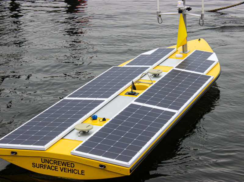
The latest technology and highlight of the event was COMIT’s un-crewed surface vessel (USV).
The USV is about 16 feet long and powered by solar panels. Massachusetts-based SeaTrac built the vessel, and it is fully autonomous. Scientists program the vessel’s mission and then remotely control it from shore, usually from a control center at the CMS.
“USVs … are really important to this effort,” said Murawski. “Because large ships, like the Hogarth you see behind me, are incapable of working in very shallow depths.”
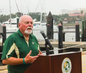
Steve Murawski is the the head of the Center for Ocean Mapping and Innovative Technologies at the USF College of Marine Science.
Murawski added that the waters surrounding Tampa Bay are notoriously shallow, which creates the need for the USV.
Murawski said the current experiment, which began earlier this week, is focused on mapping an area called the Tampa Bay Sandbox. He said this is a large area, around 90 square miles, and it extends from John’s Pass south to the shipping channels. He said the area is home to a variety of habitats, coastal margins, inlets and eelgrass, and has proven too deep or too murky to map using other technology.
“What we’re doing is trying to fill in the gaps that one technology has with the strengths of another technology,” he said.
Murawski relayed they have been mapping the southern part of the Sandbox the last few days and plan to map around Egmont Key Friday if the weather permits. He said they have already found a previously unmarked shipwreck, and while they are not sure when the vessel sank, it is estimated to be 40-50 feet long.
“Coming out of this, we will have an unprecedented map of not only the water depths but also the land adjacent to the water,” stated Murawski.
Murawski said mapping the coastal land is imperative for predicting storm surge and measuring sea level rise. He added that combining the technologies to both land and water will allow for unprecedented, detailed forecasts.
The CMS was also recently designated as the home for the new, state-funded Florida Flood Hub. Tom Frazer, dean of the CMS, called these efforts integral to the Flood Hub’s mission to improve coastal resiliency.
“It will allow us to better understand coastal flooding as a consequence of storm surge and other natural hazards,” Frazer said.
“It’s part of a comprehensive effort that we have here at the University of South Florida and the College of Marine Science to make sure we have all of the tools that we need to provide the information that will allow our decision-makers, our policymakers, our planners and all of our stakeholders to adapt and be resilient to the environmental changes we all see.”
The cost of the USV was about $30,000, and Murawski said SeaTrac gave USF a great price as the company expects to gather feedback on its vessel’s capabilities through its partnership with the school. The USV comes equipped with multiuse sonar, which sends out 1,000 beams spread out over a 120-degree angle. For comparison, Murawski said a common fish and depth finder sends out one beam directly below the boat.

The USV is remotely operated from a control room at COMIT.
Murawski made sure to explain that the sonar is not at a power level harmful to marine life.
While the National Oceanic and Atmospheric Administration (NOAA) is OMIT’s primary client, Murawski said he anticipates the State of Florida and many other agencies will use the data they collect.
“You may recall that the legislature and the governor put 100 million dollars into coastal mapping that they’re starting to execute now,” said Murawski. “Sea level rise and benchmark baseline maps are extremely important, but again, these maps will serve many purposes.
“There’s a saying in NOAA; survey map once, use many times. And they will definitely use many times.”
An accompanying press release issued by USF stated that over 50% of the nation’s Exclusive Economic Zone remains unmapped. Neil Weston, chief scientist in NOAA’s Office of Coast Survey, applauded the university for addressing that concern.
“COMIT and its partners have achieved a significant milestone in advancing USV technologies with this mission,” said Weston in the release. “Our office is particularly interested in the outcomes of these field trials, especially when new technology approaches that can improve our national priorities such as shallow water mapping, coastal resilience and emergency response.”
Moving forward, the COMIT team plans to also test sensors on drones and robotic gliders.